


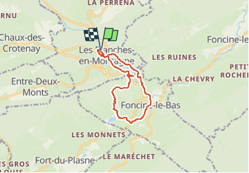
Les Planches en Montagne Gorges de la Langouette

grasgilbert
User

Length
10.8 km

Max alt
894 m

Uphill gradient
294 m
Km-Effort
14.8 km

Min alt
693 m

Downhill gradient
297 m
Boucle
Yes
Creation date :
2024-05-26 11:52:35.077
Updated on :
2024-05-29 08:04:29.673
3h05
Difficulty : Medium

FREE GPS app for hiking
 SityTrail
IGN / Geographical institutes
SityTrail Plus
The world is yours!
About
Trail Walking of 10.8 km to be discovered at Bourgogne-Franche-Comté, Jura, Les Planches-en-Montagne. This trail is proposed by grasgilbert.
Description
Très belle randonnée à faire quand il y a beaucoup d'eau
avoir une lampe pour la traversée du tunel
Photos


Positioning
Country:
France
Region :
Bourgogne-Franche-Comté
Department/Province :
Jura
Municipality :
Les Planches-en-Montagne
Location:
Unknown
Start:(Dec)
Start:(UTM)
270914 ; 5171265 (32T) N.
Comments